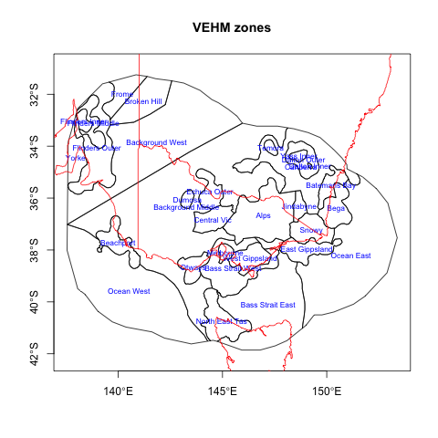
SUMMARY This report summarises the development of a new Probabilistic Seismic Hazard Analysis (PSHA) for Victoria called the Victorian Earthquake Hazard Map (VEHM). PSHA provides forecasts of the strength of shaking in any given time (return period). The primary inputs are historical seismicity catalogues, paleoseismic (active fault) data, and ground-motion prediction equations. A key component in the development of the Victorian Earthquake Hazard Map was the integration of new geophysics data derived from deployments of Australian Geophysical Observing System seismometers in Victoria with a variety of publicly available datasets including seismicity catalogues, geophysical imagery and geological mapping. This has resulted in the development of a new dataset that constrains the models presented in the VEHM and is also is provided as a stand-alone resource for both reference and future analysis. The VEHM provides a Victorian-focussed earthquake hazard estimation tool that offers an alternative to the nationally focussed 2012 Australian Earthquake Hazard Map . The major difference between the two maps is the inclusion of active fault location and slip estimates in the VEHM. There is a significant difference in hazard estimation between the two maps (even without including fault-related seismicity) due primarily to differences in seismicity-analysis. These issues are described in the discussion section of this report, again resulting in a higher fidelity result in the VEHM. These differences make the VEHM a more conservative hazard model. The VEHM currently exists as a series of online resources to help assist those in engineering, planning, disaster management. This is a dynamic dataset and the inputs will continue to be refined as new constraints are included and the map is made compatible with the Global Earthquake Model (GEM) software, due for release in late 2014. The VEHM was funded through the Natural Disaster Resilience Grants Scheme. The NDRGS is a grant program funded by the Commonwealth Attorney-General’s Department under the National Partnership Agreement on Natural Disaster Resilience signed by the Prime Minister and Premier. The purpose of the National Partnership Agreement is to contribute towards implementation of the National Strategy for Disaster Resilience, supporting projects leading to the following outcomes: 1. reduced risk from the impact of disasters and 2. appropriate emergency management, including volunteer, capability and capacity consistent with the State’s risk profile.